HIKES TOWARD COURMAYEUR

Courmayeur (TMB)

To reach Courmayeur following the official TMB path, ascend the ski slope by a path near the woods; this leads to a road. Turn left and follow it to the Monte Bianco refuge, then continue to the Maison Vieille refuge.

From there, follow the path down to Courmayeur via a mix of trails and dirt roads in the ski area.

From Refuge Maison Vieille, it is also possible to reach Courmayeur by chairlift and then by gondola (only in the high season).

Bus access to town leaves from a bus stop at the campground exit.  Timetables are displayed near the barbecue at the reception. We advise you to get off at the “Piazzale Monte Bianco” stop, roundabout at the entrance to the town where the tourist office is also located.

Checrouit swimming pool

A heated outdoor swimming pool at 1700 meters! Take a car or bus to Dolonne. From the “Piazza del Mercato” (timetables displayed near reception: the stop at the exit of the campsite “La Zerotta”) WARNING! Parking not available on Wednesday due to the market. From Dolonne take the cable car (small gondolas) to Plan Checrouit. A very short hike (5 minutes) from the top of the lifts takes one to the pool.

Alternatively, from the village of Dolonne it is possible to reach Plan Checrouit by hiking. A one hour hike- (follow the road, then the trail ((yellow signs)) above the FunPark).

Opening period from mid-July to early September.

Telephone: +39 347 4517516

Web Site

Difficulty: easy, hiking trail

Total journey time: 1h20

Notre Dame de la Guerison Chapel

Santuario Notre Dame de la Guerison

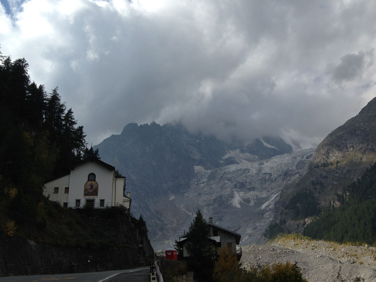
At the exit of the campsite, turn right and continue on the paved road for about 2.5 km. Possibility to reach the sanctuary on foot, by bus or by car. Opposite the sanctuary, a magnificent panoramic point over the Brenva glacier and the peaks of the Mont Blanc range.

Pascal's Meadow

Vista dal Pre de Pascal

At the exit of the campsite, turn right, cross the plateau to a road that climbs on your right. Take it and follow it to Pré de Pascal.

It is advisable to climb on foot (about 2 hours walk) or by bike because the road narrows in some places and there is no real parking at the top.

Mont Chétif (2343 mt)

Panorama Mont Chetif

Get off at Courmayeur (by bike, bus or car) and take the Val Veny cable car (it is also possible to load the bike) or walk to Pré de Pascal (about two hours from the campsite, going up to Monte Refuge Bianco and following the paved road). From Pré de Pascal, continue up the ski slope to Courba Dzeleunna. From there continue along the path to the left, reaching the top of the Zerotta chairlift. Follow the trail around the South side of the Chetif, following yellow paint markers. Climb steep, rocky terrain before exiting near the ridge that leads to the summit. Great views!

Along the way there are three points where you can climb: the degree of difficulty of the routes varies from 4 to 5c. Alternatively, it is also possible to climb Mont Chétif with the via ferrata (easy) which leaves from Dolonne in about 3 hours. WARNING! Climbing and via ferrata routes require special equipment and experience.

Difficulty: hiking

Total journey time: 1h30 from Pré de Pascal

Refuge Maison Vieille (altitudine 1956 mt)

A pleasant alternative to reach the refuge without leaving the campsite on foot . (See the route “towards the Monte Bianco refuge”) Descentd to Courmayeur (by bike, bus or car) and take the Val Veny cable car  located at the foot of the Val Veny (not in town). This lift is also bike friendly, and takes one to the Pré de Pascal: from here follow the directions for the Refuge Maison Vieille (about 50 minutes): go up the ski slope to the Courba Dzeleunna,  then descend a steep road, still following the ski slopes (route also suitable for mountain biking).

During the months of July and August it is also possible to reach the refuge comfortably by chairlift.

In this case you take the cable car which leaves from Dolonne, from just outside the Courmayeur village and arrive at Checrouit. From there 200m flat walk to the Maison Vielle chairlift which arrives near the refuge (for timetables and prices consult this link).

Starting from Dolonne on foot, the refuge can be reached in around 2 hours.

N.B. It is advisable to taste the dessert “pain perdu”, a French specialty made with stale bread soaked in milk and sugar then cooked in a pan with an egg and butter, then served with cream.

Opening period from mid-June to end of September

Telephone: 337 230979 or 328 0584157

Difficulty: easy, hiking trail

Total walking time: 1h30

Lake Checrouit (altitude 2165 mt)

Lago dello Checrouit

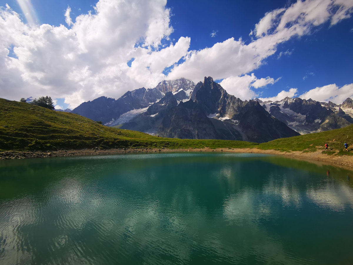
Once you have arrived at the Refuge Maison Vielle (see information on the Refuge Maison Vieille) follow the signs indicating Lac Checrouit, the path that goes up to the right (return to the refuge). Along the way, several panoramic points allow you to admire the Mont Blanc range in all its splendor. After a little less than an hour’s walk, you reach the lake.

Difficulty: hiking trail

Total walking time: from the campsite to the lake 2h30

Balcony of Val Veny

From the Refuge Maison Vielle (see information for the Refuge Maison Vielle) follow the signs indicating Lac Checrouit, a path ascending to the right. After a little less than an hour’s walk, you reach the lake. If you wish, it is possible to continue the path along the whole Val Veny balcony, eventually descending to the Combal lake.

Balconata Val Veny

Difficulty: hiking trail

Total travel time: from the campsite to the lake 2h30 to arrive at Lac de Combal, count another 1h30 and 30/40 additional minutes to La Visaille where you can take the bus or another 45 minutes on foot to return to the campsite) .


WALKS IN VAL-FERRET

La Suche Dormitory

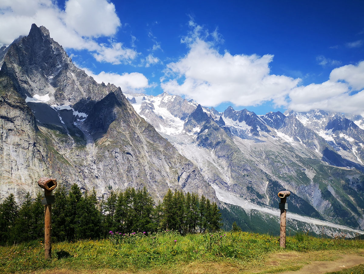
From Courmayeur, follow the road through La Villain, and ascends to the Ermitage. Follow trail no. 40, climbing through the forest,  until you reach La Suche. Spectacular panorama of the Mont Blanc range.

It is possible to choose to continue in the direction of Tirecorne (either on the way up, or from La Suche) for half an hour, then go down to the Hermitage and thus complete a loop.

Difficulty: hiking.

Col Licony- Lake Licony- Bivacco Pascal

From La Suche, follow the signs indicating the Col Licony which you reach after about 2h30/3h of walking. Possibility of descending to Lake Licony

From the pass, it is also possible to continue along the path to the right for another 45 minutes/1 hour to Bivouac Pascal.

Difficulty: hiking, long 

Bertone Refuge (altitude 2000 mt)

Reach Courmayeur and take the bus from Piazzale Monte Bianco (entrance roundabout to Courmayeur where the transport office is also located. WARNING! Buying the ticket on the bus incurs a surcharge! Tickets can be purchased at the reception. Val Veny and Val Ferret timetables displayed on the barbecue,  and available on this site 

Get off at the Loc.Planpincieux stop, cross the bridge and follow the path to Refuge Bertone, accessible in about 1h30 by a beautiful panoramic path with a view of the Mont Blanc range.

Another option from the center of Courmayeur- Follow the direction of Villair (Val Sapin). Continue through the Villair hamlet, ascending alone the road. Eventually yellow markers indicate the trail to the hut on the left. A steeper path that always takes about an hour and a half from Villair.

Opening period from June to September

Telephone: 0165 844612 or 348 0056203 (Lorenzino Cosson owner) 347 0325785 (Alice)

Difficulty: hiking

Travel time: 1h30 from Planpincieux

Mount Saxony, Testa Bernarda (altitude 2534 mt)

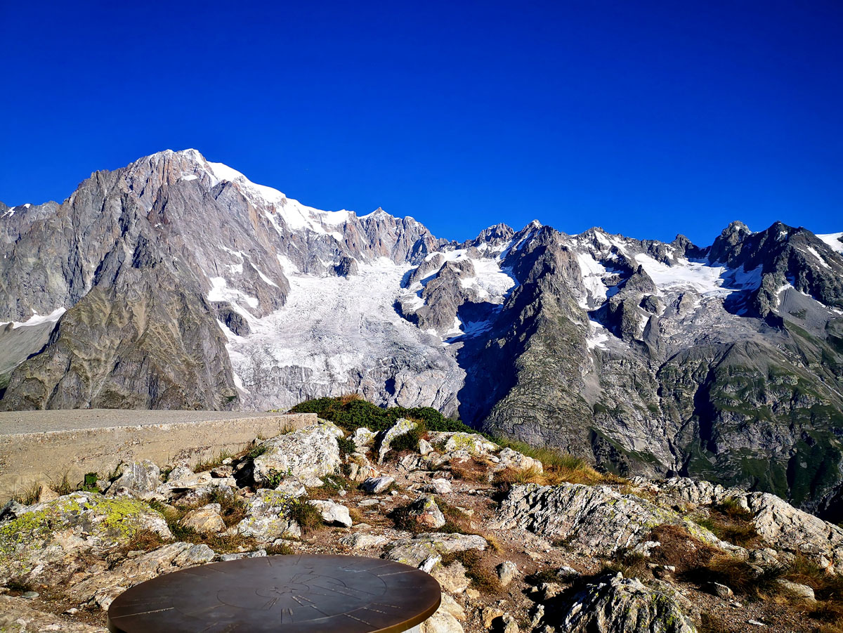
From the Rifugio Bertone, continue climbing until you find an orientation table. From here, continue following indications for the Mt Saxony and the Testa Bernarda. A meadowed ridge leads first to the Mont de la Saxe, then on to the Testa Bernarda and the Tête de la Tronche (2584 m). Amazing views!!

Difficulty: hiking

Travel time: 2 hours from the Bertone refuge

Boccalatte refuge (altitude 2803 mt)

From Courmayeur take the bus from the  Piazzale Monte Bianco (entrance roundabout to Courmayeur where the tourism office is also located.) WARNING! Buying the ticket on the bus incurs a surcharge! Tickets can already be purchased at the reception. Val Veny and Val Ferret timetables displayed near the barbeque and are available on the site-

https://aosta.arriva.it/courmayeur-mont-blanc/  

Get off at the Planpincieux stop and follow path no. 21 on the left. After about 40 minutes you come to a fork. Follow yellow arrows entering the forest. Pass in front of the small chapel of Planpincieux, heading toward seracs, over two gullies, to an obvious waterfall with steps of I-II degrees. Continue on the right ridge to a metal staircase which leads to the ascent of a chimney. Follow a moraine ridge to its terminus. Move left towards the refuge, finally arriving via climbing a ramp and using fixed ropes.

WARNING! The path undergoes continuous changes following landslides in the fall of 2019. Danger of rockfall!

Difficulty: expert hikers

Travel time: 3h30

Planpincieux : bar restaurant, bike rental, horse riding, playground, paintball

From Courmayeur take the bus from the  Piazzale Monte Bianco (entrance roundabout to Courmayeur where the tourism office is also located.) WARNING! Buying the ticket on the bus incurs a surcharge! Tickets can already be purchased at the reception. Val Veny and Val Ferret timetables displayed near the barbeque and are available on the site-

 https://aosta.arriva.it/courmayeur-mont-blanc/  

Get off at the Loc.Planpincieux stop. There are several bars/restaurants-

Lo Brenlo +39 0165869715, Chalet Proment +39 0165897006, La Clotze +39 0165 869720, Miravalle +39 0165869777, Locanda Belvedere +39 0165869701

Paintball tel: +39 348 652 14 68

Club des Sports for the rental of bicycles, trampolines, etc. +39 016589570

Horse riding (Sylvie +39 3923723761)

Lavachey: sport fishing

From Courmayeur take the bus from the  Piazzale Monte Bianco (entrance roundabout to Courmayeur where the tourism office is also located.) WARNING! Buying the ticket on the bus incurs a surcharge! Tickets can already be purchased at the reception. Val Veny and Val Ferret timetables displayed near the barbeque and are available on the site-

 https://aosta.arriva.it/courmayeur-mont-blanc/  

Get off at the Lavachey stop, on the right near the sport fishing. It is possible to fish for trout, salmon trout, arctic char, brown trout and sturgeon. Open from mid-June to the end of September all day from 9 a.m. to 6.30 p.m.

For fishing permits, contact the Bar Lo Brenlo at Loc Planpincieux (telephone +39 0165869715). To fish in the reserve, if you don’t have a state permit, it costs €41, if you do, it costs €31. Free day pass €19 if you don’t have the Valle d’Aosta card.

Bonatti Refuge (altitude 2026 mt)

From Courmayeur take the bus from the  Piazzale Monte Bianco (entrance roundabout to Courmayeur where the tourism office is also located.) WARNING! Buying the ticket on the bus incurs a surcharge! Tickets can already be purchased at the reception. Val Veny and Val Ferret timetables displayed near the barbeque and are available on the site-

 https://aosta.arriva.it/courmayeur-mont-blanc/  

Get off at the Loc.Lavachey-Rif Bonatti stop and follow the path to the Bonatti Refuge, accessible in about 1 hour. Another route just after the bridge on the right follows a slightly less steep path and reaches the refuge in about 1 hour.

Opening period from June to September

Telephone: +39 01651855523, +39 01651827229, +39 3356848578

Difficulty: hiking

Walking time: 1 hour

Balcony of Val Ferret

From the Refuge Bonatti, it is possible to take the magnificent coastal path that leads to Refuge Bertone in about an hour and a half, thus enjoying an incomparable panorama of the Mont Blanc range. Highly recommended!!

Bivouac Gervasutti (altitude 2835 mt)

From Courmayeur take the bus from the  Piazzale Monte Bianco (entrance roundabout to Courmayeur where the tourism office is also located.) WARNING! Buying the ticket on the bus incurs a surcharge! Tickets can already be purchased at the reception. Val Veny and Val Ferret timetables displayed near the barbeque and are available on the site-

 https://aosta.arriva.it/courmayeur-mont-blanc/  

Get off at the Loc.Lavachey stop. Continue for 700 meters along the road until you find an iron bridge on the left crossing the Dora Ferret mountain stream, with indications for the bivouac (it is also possible to start on the old path near the Frébouze bridge, to then join the new route).

Go up the moraine of the glacier following the cairns and the sparse yellow marks. Pass a gully and via a steep slope you arrive at another gully (50m of fixed ropes) that you can climb easily. Continue to climb reaching an area of ​​rubble, passing various slabs until reaching the terminal tongue of the glacier, which descends on the orographic left of the rocky islet on which the bivouac stands. Follow the yellow markings and climb the low wall (30 meters, fixed rope) to the bivouac.

If the bergschrund is too open you may have to climb to the right, and approach the bivouac from above.

Difficulty: experienced hikers/ alpinists with proper equipment for glacier travel and climbing

Refuge Elena (altitude 2061 mt)

From Courmayeur take the bus from the  Piazzale Monte Bianco (entrance roundabout to Courmayeur where the tourism office is also located.) WARNING! Buying the ticket on the bus incurs a surcharge! Tickets can already be purchased at the reception. Val Veny and Val Ferret timetables displayed near the barbeque and are available on the site-

 https://aosta.arriva.it/courmayeur-mont-blanc/  

Get off at the Loc.Arpnouvaz stop (terminus). Follow the trail to the Refuge Elena, reachable in about 45 minutes.

Alternative route from the car park, follow the road that reaches the refuge in about 1 hour. Can also be done by mountain bike.

Opening period from July to September

Telephone: +39 0165844688

Difficulty: hiking

Walking time: 1 hour

Gran Col Ferret and Bivouac Fiorio (altitude 2810 mt)

From Courmayeur take the bus from the  Piazzale Monte Bianco (entrance roundabout to Courmayeur where the tourism office is also located.) WARNING! Buying the ticket on the bus incurs a surcharge! Tickets can already be purchased at the reception. Val Veny and Val Ferret timetables displayed near the barbeque and are available on the site-

 https://aosta.arriva.it/courmayeur-mont-blanc/  

Get off at the Loc.Arpnouvaz stop and reach the Elena refuge. From there, follow the directions for the Gran Col Ferret, which can be reached in around 1h30 on foot (altitude 2535 m). The pass is located on the border with Switzerland (direction La Peule, La Fouly, etc.). Once at the top, follow the path left towards the Bivacco Cesare Fiorio which is reached in circa 1 hour following the trail The last section is on rocky ground, following yellow marks and the cairns. It is possible to climb directly to the bivouac with a path starting near the Elena refuge. This is a steeper path on grassy slopes, rubble, and slabs that are often slippery and wet. We advise you to do be careful, and follow this path for the climb and then descend via the Gran Col Ferret path.

Difficulty: expert hikers

Travel time: 2h30

Bivouac Comino (altitude 2430 mt)

From Courmayeur take the bus from the  Piazzale Monte Bianco (entrance roundabout to Courmayeur where the tourism office is also located.) WARNING! Buying the ticket on the bus incurs a surcharge! Tickets can already be purchased at the reception. Val Veny and Val Ferret timetables displayed near the barbeque and are available on the site-

 https://aosta.arriva.it/courmayeur-mont-blanc/  

Get off at the Loc.Arpnouvaz stop. Continue on the road until you find the signs for the Comino bivouac on the left (path no. 22) The path follows the Dora stream, then climbs steeply along the moraine descending  from the Triolet glacier (watch for cairns and yellow marks- the route is not always clear). A short snowy slope (until late in the season) leads to a left turn, and the trail follows arrows on the rocks. Leave the moraine and climb granite slabs interspersed with rhododendron bushes until you reach the bivouac. (Warning! The moraine is quite treacherous and slippery. On very warm days the return via the two bridges over the Dora could be difficult due to meltwater.

Difficulty: expert hikers

Travel time: 2h30

Dalmazzi Refuge (altitude 2584 mt)

From Courmayeur take the bus from the  Piazzale Monte Bianco (entrance roundabout to Courmayeur where the tourism office is also located.) WARNING! Buying the ticket on the bus incurs a surcharge! Tickets can already be purchased at the reception. Val Veny and Val Ferret timetables displayed near the barbeque and are available on the site-

 https://aosta.arriva.it/courmayeur-mont-blanc/  

Get off at the Loc.Arpnouvaz stop. Follow the road until you find signs for Refuge Dalmazzi on a bend to the left. The trail first climbs between large boulders to a grassy hilltop, then joins the lateral moraine of the Triolet glacier. Follow the light yellow markings that go up the moraine between easy rocks with a few passages equipped with fixed ropes and metal steps on a rocky outcrop. The last section winds between meadows and rocky slabs, and you will soon arrive at the refuge in a panoramic position. It is possible to continue the path above the hut, enjoying a magnificent view.

Difficulty: expert hikers

Travel time: 2h30